ATAK-CIV (Civil Use)
- 3.7
- Rating
- 500.00K
- Installs
- Free
- Price

 Analysis by App-foxy
I approached ATAK-CIV as a serious field-mapping tool rather than as another turn-by-turn navigation app. It is built for geospatial and situational awareness, and that difference becomes clear almost immediately: the focus is not simply on getting from one address to another, but on understanding a place, marking information, and keeping a shared operational picture readable. If you enjoy working with maps in detail, this Android app has much more depth than its short store label suggests.
My experience was positive when I treated it as a planning and coordination workspace. It feels far less natural if all I want is a quick route to a shop or a familiar destination. That distinction is the key to deciding whether it belongs on your phone. ATAK-CIV is free, developed by TAK Product Center, and listed for Teen users. It is available for Android devices running Android 5.0 or later, which makes its technical reach broad, although the experience still depends heavily on the phone’s screen, GPS performance, and the quality of the map material available to you.
How I use ATAK-CIV as a repeatable field workflow
I use ATAK-CIV as a repeatable field workflow by keeping preparation, active use, and cleanup as separate steps: first I check the area, then add only the references that support a decision, and finally review the map from another person’s point of view. That routine makes it easier to notice when a marker is unclear or a view is too crowded. Next, I focus on recovering the workflow when something on the screen does not behave as expected.
You May Also Like

 Blood Strike: 2.5 Anniversary
Blood Strike’s Loadouts Turn Every Drop Into a Tactical Gamble
A close look at Blood Strike’s custom loadouts: how fast access to signature weapons reshapes its battle royale rhythm, rewards preparation, and narrows the gap between fights.

 Pandora - Music & Podcasts
Pandora’s Music Is Easy to Start, but Harder to Recover
Pandora’s strength is its low-effort path from a seed to a station. Its weak spot is how much confidence it asks you to place in connection, setup, and quiet recovery.

 8 Ball Pool
 Is Built on Rivalries, Rematches, and Routine
A close look at the rivalries, rematches, shared routines, and unanswered safety questions that turn a quick pool match into a persistent mobile community.

 Samsung Music
’s Quiet Strength Is Playing What You Already Own
Its reach comes less from spectacle than from dependable access to a personal library. That simplicity is both the app’s strongest retention engine and its ceiling.

 AccuWeather: Weather Radar
AccuWeather Review: A Quick, Clear Forecast for Everyday Decisions
For everyday plans, the best forecast is the one you can understand quickly. AccuWeather makes rain timing, radar, and local conditions easy to act on, with a few trade-offs.

 Hill Climb Racing
Why Hill Climb Racing Still Turns Crashes Into One More Run
A tiny car, a bumpy hill and one more upgrade: Hill Climb Racing keeps resurfacing because its simple chaos makes every near-miss feel personal.
More From Our News Desk



Start with the map, not the destination box
My first habit with ATAK-CIV is to avoid treating the opening map like a conventional navigation screen. I begin by deciding what I need to understand: terrain, access points, a meeting area, a route corridor, or a set of locations that need attention. That small change in mindset makes the interface easier to read because every marker and line has a purpose instead of becoming visual clutter.
A practical baseline workflow is simple. I open the map, confirm that the visible area is the one I intend to work with, establish my own position, and then add only the points that matter to the task. After that, I inspect the route or area at different zoom levels. At a wider view, I look for the overall relationship between locations. At a closer view, I check whether the proposed path actually makes sense around roads, open ground, boundaries, and other visible map details.
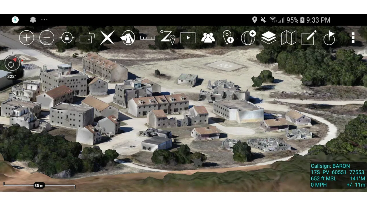
This is one of the app’s strongest qualities: it encourages preparation before movement. A conventional maps app usually gives priority to a destination and a route. ATAK-CIV gives more attention to the information surrounding that route. I found that useful when planning a walk through an unfamiliar area, checking several possible meeting points, or preparing a map to show someone else instead of merely following spoken directions.
Keep markers meaningful
The easiest way to make a detailed map unhelpful is to mark everything. I had better results when I used a small vocabulary of markers and applied it consistently. One point might represent a meeting location, another a hazard or obstruction, and another a useful reference. The exact meaning matters less than using the same meaning every time.
I also avoid placing a marker simply because a location looks interesting. Before adding one, I ask whether it changes a decision. If it does not affect movement, safety, timing, or coordination, I leave it out. This is a surprisingly valuable habit because ATAK-CIV can present a lot of information, and a crowded display makes important items harder to find.
When I prepare a map for someone else, I review it as a reader rather than as its creator. I hide or remove anything that is no longer relevant, check that labels are understandable, and make sure lines do not cross the points they are meant to explain. This review step is more important than adding another layer of detail. A clean map can communicate quickly; a busy one can force the other person to ask questions that the map should have answered.
Use it for everyday planning, with realistic expectations
A realistic everyday scenario would be organizing a volunteer cleanup in a large park. I could use ATAK-CIV to identify the meeting point, mark supply drop locations, outline the area to cover, and note access points that different people should use. The value is not that the app replaces a normal navigation tool. The value is that everyone can discuss the same geography and see how separate tasks fit together.
Another useful scenario is a hiking group preparing a route with several regrouping points. I would inspect the map before leaving, mark the points where the group expects to pause, and keep the map focused on the route rather than filling it with unrelated locations. If plans change, the map can be adjusted as a working document instead of relying on memory or a long message thread.
For ordinary commuting, restaurant searches, traffic awareness, or public-transit directions, I would choose a mainstream maps app instead. Those products are usually faster for address search, business information, spoken guidance, and familiar route choices. ATAK-CIV earns its place when the map itself is the object of the work.
What the current release feels like in practice
The current version is 5.6.0.12 (9c9a5897), and the app has reached more than half a million installs. Its average rating is 3.7 from around 1.7 thousand ratings, with nearly three hundred written reviews. I read those figures as a useful warning against assuming that a specialized tool will feel effortless for everyone. The audience is large enough to show that the concept has practical appeal, but the rating also suggests that setup, interface complexity, or device-specific behavior may frustrate casual users.
I would not judge the app by the standards of a polished consumer navigation service. Its strengths are control, map-based organization, and situational context. Its weaker side is the amount of attention it asks from the user. You need to understand what you are displaying, why you are marking it, and how the information will be interpreted later.
Settings I check before relying on a map
My first checks are the map display and position behavior. I want to know whether my location is being shown in a way I can interpret quickly, whether the map orientation feels natural for the task, and whether the visible detail changes sensibly as I zoom. These choices sound minor, but they affect how quickly I can compare my position with a route or a marked area.
I also check what is visible before beginning a session. If several categories of information are enabled at once, the screen can become difficult to scan. I prefer starting with a restrained view and adding detail only when it answers a specific question. This is especially helpful on a phone, where the display gives less room for labels and overlapping symbols than a larger screen.
Another worthwhile check is the behavior of any map material I plan to use. A map that looks useful at one zoom level may not provide the same clarity at another. Before leaving a reliable connection, I inspect the areas I expect to need and make sure I understand what will actually be available during the task. I treat this as a planning discipline rather than assuming that a map screen automatically guarantees dependable access everywhere.
Location accuracy is equally important. I do not use the position indicator as if it were a perfect dot on the ground. Near buildings, dense vegetation, or complicated terrain, the displayed position may require interpretation. I compare it with visible roads, paths, landmarks, and the direction of travel. That extra pause prevents a small positioning error from turning into a bad decision.
Make the phone easier to use before the work begins
ATAK-CIV rewards users who prepare the device itself. I keep the screen clean, make sure the phone is sufficiently charged, and avoid beginning with a dozen unrelated apps competing for attention. If I expect to work outdoors, I also think about glare and how quickly I can read labels without stopping for a long time.
I recommend testing the exact workflow before using it in a situation where mistakes matter. Open the map, create a sample point, inspect it at different zoom levels, and remove it afterward. Try the actions you expect to repeat. This reveals interface friction early and helps build muscle memory without inventing a complicated system around the app.
Permissions and device behavior deserve the same practical attention. Since the app depends on geospatial awareness, I check that location access behaves as expected on my phone and that the operating system is not aggressively interrupting the app. I do not assume that a setting that worked on one Android device will feel identical on another. The minimum supported Android release is 5.0, but newer hardware can still provide a more comfortable experience through a larger display, better positioning hardware, and smoother multitasking.
Shortcuts come from habits, not magic
The fastest ATAK-CIV users I know are not necessarily pressing obscure controls constantly. They are repeating a small number of reliable actions. I use a rhythm of inspect, mark, verify, and clean up. First I inspect the area, then I add a point or line, then I verify its placement and meaning, and finally I remove anything unnecessary. Repeating that sequence is quicker than adding information randomly and correcting the map later.
I also separate planning from live use. During planning, I can afford to explore, compare views, and revise markings. During movement or coordination, I want a simpler display and fewer decisions. Preparing the map in advance means that I am not trying to build the whole picture while also paying attention to the environment.
One non-obvious advantage of this approach is that it improves communication. A marker is not just a private reminder; it can become a shared reference. If I use clear labels and consistent placement, another person can understand the map without hearing a long explanation. If I use vague labels or duplicate points, the app becomes a source of ambiguity rather than clarity.
I find it helpful to use progressive detail. At the beginning, I work with the broad area and the main route. Then I add only the details needed for the next decision. This avoids the common mistake of zooming in too early and losing the wider relationship between locations. When I need to explain the plan, I can zoom out again and show the structure without deleting the useful close-up information.
Where the advanced workflow reaches its limits
ATAK-CIV is not a universal replacement for every mapping service. Its specialized approach means that a beginner may spend more time learning the interface than expected. If you want instant search, polished turn-by-turn voice guidance, business listings, or an effortless commute, this is probably the wrong first choice.
The phone form factor is another limitation. Detailed spatial work can become tiring on a small screen, especially when several symbols or labels are close together. I can reduce clutter and work in stages, but that does not change the physical limits of reading a complex map on a handset. A larger device may be preferable for preparation, while the phone remains useful for carrying the working map.
There is also a human reliability problem. A sophisticated map can create false confidence if the user assumes that every displayed detail is current, precise, or relevant. I treat the app as an aid to observation and planning, not as permission to ignore conditions on the ground. Routes can be blocked, landmarks can change, and a location indicator can be imperfect. The more important the decision, the more I cross-check what I see.
Sharing and coordination also require discipline. A map only helps a group if everyone understands the symbols, labels, and intended use. Before relying on a shared view, I explain the few conventions that matter and remove information that could be misread. The trade-off is clear: ATAK-CIV can support a richer common picture than a simple text message, but it asks the group to agree on how that picture should be read.
Who should use it, and who should skip it
I would recommend ATAK-CIV to hikers who like planning in detail, volunteer coordinators, outdoor teams, field researchers, and technically confident users who need more than a destination pin. It is particularly suitable for people who think spatially and are willing to create a repeatable map workflow. The free price makes experimentation easy, so curious users can test whether the approach fits before committing money.
I would skip it if my main need were finding a business, avoiding traffic, following spoken directions, or receiving the simplest possible route. I would also be cautious about recommending it to someone who dislikes map configuration or wants the app to make every decision automatically. The Teen content rating is another reason parents and younger users should consider whether the app’s intended style of use matches their needs.
Compared with ordinary navigation apps, ATAK-CIV gives me a more deliberate way to organize geographic information, but it gives me less of the consumer convenience I expect from those alternatives. Compared with a paper map, it offers a more interactive working space, while introducing dependence on a phone, its positioning behavior, and the user’s preparation. Neither comparison makes it universally better; they show where its design is most useful.
My verdict after building a repeatable routine
ATAK-CIV is best understood as a field map and situational-awareness workspace, not as a standard navigation shortcut. Once I stopped expecting it to behave like a typical directions app, its strengths became much clearer. I could plan around areas instead of single destinations, keep important points together, and adjust the display to match the question I was trying to answer.
The app’s real learning curve is not just finding controls. It is learning to manage information: choosing meaningful markers, checking the map at more than one scale, preparing before movement, and keeping the display readable for other people. Those habits make the experience faster and safer than simply adding every available detail.
My final recommendation is therefore specific. Try ATAK-CIV if you need a structured geographic picture and are prepared to spend time learning a workflow. Use a conventional maps app when convenience, search, traffic, or spoken guidance matters more. For the right user, this free Android app is a capable and unusually focused tool; for everyone else, its depth may feel like unnecessary work. I appreciate it precisely because it does not pretend that complex field planning can be reduced to one destination and one blue line.
FAQs for ATAK-CIV (Civil Use)
01What is ATAK-CIV (Civil Use), and who is it designed for?
ATAK-CIV is a civilian version of the Android Team Awareness Kit, a mapping and situational-awareness application built around location sharing, digital maps, team coordination, and field information. It can be useful for search-and-rescue groups, emergency responders, outdoor teams, disaster-relief organizations, and other users working in changing environments. It is a specialized tool rather than a typical navigation app, so new users may need time to understand its interface and terminology.
02Does ATAK-CIV require an internet connection to work?
ATAK-CIV can support offline field operations when suitable maps, imagery, elevation data, and other required content have been downloaded or installed in advance. However, online connectivity may still be needed to obtain map sources, exchange information through configured services, or update certain data. Location tracking itself generally depends on the device’s GPS or other positioning hardware, but performance can vary indoors, under heavy cover, or in areas with a weak satellite signal.
03Can ATAK-CIV share my location with other people?
Yes, ATAK-CIV is designed to support team awareness and can share position information when the application is connected to a compatible network or configured communication service. The exact features available depend on the setup, plugins, server infrastructure, and permissions used by the organization. Users should understand that sharing location data can reveal sensitive information, so communication settings, trusted contacts, and privacy practices should be reviewed carefully before using the app in the field.
04Is ATAK-CIV easy for beginners to use?
ATAK-CIV offers powerful tools, but it is not necessarily beginner-friendly in the same way as mainstream map applications. The interface includes layers, markers, routes, overlays, communication functions, and specialized tools that may initially feel complicated. A short learning period is recommended, especially for users who need reliable performance during emergencies or remote activities. Practicing with downloaded maps and basic features before deployment can make the experience considerably easier.
05What permissions and device requirements does ATAK-CIV need?
ATAK-CIV commonly requires access to location services so it can display the device’s position and support navigation or team tracking. Depending on the functions and plugins being used, it may also need permissions for storage, network communication, notifications, Bluetooth, or other device features. Requirements can vary by version and installation source. Before downloading, check the current listing and your organization’s guidance, and only grant permissions that are necessary for the features you intend to use.
Pros
- Powerful offline mapping and navigation capabilities.
- Supports detailed terrain
- satellite
- and topographic map layers.
- Offers extensive tools for marking and sharing locations.
- Useful for search-and-rescue and outdoor coordination teams.
- Can integrate with compatible plugins and external devices.
Cons
- The interface can feel overwhelming for first-time users.
- Many advanced features require significant setup and training.
- Map data and plugins may need manual downloading or updating.
- Battery and storage use can increase during extended fieldwork.
- Some collaboration features depend on compatible servers or devices.

ATAK-CIV (Civil Use)
Gallery